
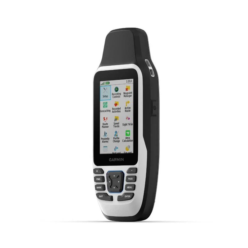
Description
- Physical Dimensions: 6.77 x 17.40 x 4.23 cm
- Display Size: 3.8 x 6.3 cm; 3″ diag (7.6 cm)
- Display Resolution: 240 x 400 pixels
- Display Type: Transflective 65K colour TFT
- Weight: 282g with batteries
- Battery Type: 2 AA batteries (not included); NiMH or Lithium recommended
- Battery Life: Up to 19 hours
- Water Rating: IPX7
- MIL-STD-810: Yes (thermal shock water); bare unit only
- Interface: High speed microUSB and NMEA 0183 compatible
- Memory/History: 8 GB
Cast Off Confidently
Stay on course and track more adventures with the GPSMAP® 79s rugged floating handheld.
- It’s water-resistant it floats and it’s fogproof so it belongs on the water
- This thing can remember up to 10 000 waypoints and more.
- It’s nice to have reliable positioning when out on the water.
- The built-in compass will point in the right direction.
- Get the best of Garmin and Navionics® data with optional BlueChart® g3 charts.
- Stay out longer with up to 19 hours of battery life in GPS mode.
Built for life on the boat.
Rugged Handheld: This handheld is water-resistant IPX7 with a high-resolution colour display that can be read in the sun. The glass is even scratch-resistant and fogproof.
Designed to Float: If rough waters come and the handheld goes overboard don’t worry. This device floats.
Battery Life: User-replaceable AA batteries (not included) provide up to 19 hours of battery life in GPS tracking mode.
Exactly what is needed to navigate.
Accurate Tracking: With support for multiple satellite constellations — such as GPS GLONASS Beidou Galileo QZSS and SBAS — Get accurate reliable tracking and positioning around the world.
Increased Memory: More memory than previous models Save and track 10 000 waypoints 250 routes and 300 fitness activity files.
Built-In Compass: The 3-axis tilt-compensated electronic compass shows the heading — even while the boat is standing still.
General |
|
| Lens material |
chemically strengthened glass |
|---|---|
| Dimension | 6.77 x 17.40 x 4.23 cm |
| Weight | 282g with batteries |
| Water rating | IPX7 |
| MIL-STD-810 | Yes (thermal, shock, water); bare unit only |
| Display Type | Transflective, 65K colour TFT |
| Display Size | 3.8 x 6.3 cm; 3″ diag (7.6 cm) |
| Display Resolution | 240 x 400 pixels |
| Battery type | 2 AA batteries (not included); NiMH or Lithium recommended |
| Battery life | Up to 19 hours |
| Memory/history | 8 GB |
| Interface | High speed microUSB and NMEA 0183 compatible |
Maps & memory |
|
| Preloaded maps | None |
|---|---|
| Ability to add maps | |
| Basemap | |
| Automatic routing (turn by turn routing on roads) for outdoor activities | Yes (with optional mapping for detailed roads) |
| Map segments | 15,000 |
| Includes detailed hydrographic features (coastlines, lake/river shorelines, wetlands and perennial and seasonal streams) | Yes (downloadable from Garmin Express™) |
| Includes searchable points of interests (parks, campgrounds, scenic lookouts and picnic sites) | Yes (downloadable from Garmin Express™) |
| Displays national, state and local parks, forests, and wilderness areas | Yes (downloadable from Garmin Express™) |
| Storage and Power Capacity | Yes (32 GB max microSD™ card, not included) |
| Waypoints/favourites/locations | 10,000 |
| Tracks | 250 |
| Navigation Track Log | 20,000 points, 250 saved gpx tracks, 300 saved fit activities |
| Navigation Routes | 250, 250 points per route; 50 points auto routing |
| Rinex logging |
Sensors |
|
| GPS | |
|---|---|
| Galileo | |
| QZSS | |
| SBAS | |
| Compass | Yes (tilt-compensated 3-axis) |
| High-sensitivity receiver | |
| GPS compass (while moving) |
Outdoor recreation |
|
| Point-to-point navigation | |
|---|---|
| Area calculation | |
| Fish forecast | |
| Geocaching-friendly | Yes (paperless) |
| Custom maps compatible | |
| Picture viewer |
Security Information |
|
| Security updates until at least (YYYY-MM-DD) | 2023-10-26 |
|---|

Reviews
There are no reviews yet.